Image, Shutterstock; Radio731 logo courtesy of Forever Communications; Lindsey Electric logo courtesy of Lindsey Electric; designed by TTR
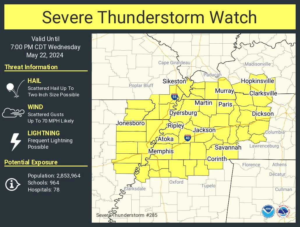
THe National Weather Service in Memphis has issued a severe thunderstorm watch for West Tennessee, East Arkansas and North Mississippi. The watch will be in effect until 7 p.m. Wednesday, May 22, 2024.
In West Tennessee, the following counties will be in the watch: Benton, Carroll, Chester, Crockett, Decatur, Dyer, Fayette, Gibson, Hardeman, Hardin, Haywood, Henderson, Henry, Lake, Lauderdale, Madison, McNairy, Obion, Shelby, Tipton, and Weakley.
This includes the cities of Alamo, Ashland, Bartlett, Blytheville, Bolivar, Brownsville, Camden, Caruthersville, Collierville, Corinth, Corning, Covington, Decaturville, Dresden, Dyersburg, Forrest City, Germantown, Harrisburg, Henderson, Holly Springs, Humboldt, Huntingdon, Jackson, Jonesboro, Kennett, Lexington, Marianna, Martin, Memphis, Milan, Millington, Oakland, Olive Branch, Paragould, Paris, Parsons, Piggott, Ripley Ms, Ripley, Savannah, Selmer, Senatobia, Somerville, Southaven, Tiptonville, Tunica, Union City, West Memphis, and Wynne.
A Severe Thunderstorm Watch: Be Prepared! Severe thunderstorms are possible in and near the watch area. Stay informed and be ready to act if a severe thunderstorm warning is issued. The watch area is typically large, covering numerous counties or even states.
Our severe weather coverage is sponsored by Lindsey Electric, your Generac generator dealer in Jackson. Call 731-423-1580, or visit Lindsey Electric Service dot com. Lindsey Electric – The authority for your power solutions.